Oliver (Johny Connors) Lake

This is a small site located in a scenic alpine basin with a shallow lake. There is a short trail on the east side of the road to the shallow lake and around it. Access can also be gained to the surrounding ridges, although there are no developed trails.

Driving Directions:From the community of Crawford Bay, head south for 200 meters on Highway3A, and then turn left on Oliver road just past the Gray Creek store. Follow this road for 300 meters and then turn right, crossing Grey Creek. Follow this road , now called Anderson road, for 1.3 km, turning left at the junction. Follow the main Grey Creek road 15.0 km to the campsite.

Ross Lake Trail

The Ross Lake trail offers a sub-alpine experience for the whole family. This is a short,but rough, trail that ends at a small alpine lake and provides access to the surrounding ridge system. The primary activities are hiking, fishing, and camping.

Driving Directions:From the ferry terminal at Balfour, travel west on highway #3A for 2.7 km to Beggs Road on the right. Keep to the left, and follow Beggs road for 0.8 km to a fork in the road. Stay left and drive 0.3 km to Redfish Forest service road on the left (cross over Laird Creek). Follow Redfish forest service road (keep right at the junction with the Redfish Research Area) for 10.3 km to a bridge. Drive across the bridge and drive the remaining 1.0 km to a road that leads to the right. The bridge across this road is damaged, so you will need to walk the remaining portion of the road to the trailhead. The trail begins on an old skid trail to the north-west.

Old Glory Lookout

The Old Glory Trail is a ridge-hikers delight. The trail provides access to many kilometres of open easy ridge hiking with great views. The first section of this trail is a gentle grade that leads through a stand of large cedar and hemlock on the south side of Hanna Creek drainage and then enters an old cutblock. As the trail nears the end of the cutblock at 1.2 km the grade steepens and at times may be overgrown with alder. Hikers would be well advised to bring raingear for this section if it is wet. At 3.2 km the trail reaches a low saddle on the ridge that is called “Unnecessary Ridge” by locals. From here there are several unmanaged trails that join the main trail. Old Glory trail lies to the right, and is marked with a small sign. Turning up the ridge, the grade becomes gentler and the sub-alpine forest opens up to allow glimpse views to both sides of the ridge. The trail continues at a moderate to gentle grade, winding its way up the ridge and starting into an old burn at 4.5 km. At 6.5 km the trail reaches a junction with Plewman Trail. From here Old Glory Peak is 2.0 km. From here the trail user has the option of following Plewman Trail down the other side of the Hanna Creek drainage to the trailhead (4.5 km), or continuing on to Old Glory. The Forest Service fire lookout building perches at the very peak at an elevation 2376 m / 7795 ft. From this lofty perch 360 degree views of the surrounding areas reveal Goat Mountain and Big Sheep Creek drainage to the west, Mt. Plewman and Highway 3 to the north and east, the view back down Unnecessary Ridge, Mt. Kirkup, Grey Mountain and Granite Mountain to the east, and Esling Creek drainage to the south.

Driving Directions: From the Museum in Rossland follow the highway north for 10 km to the trailhead on the west (left) side of the highway. The trailhead can be hard to find. Look for a 4 x 4 sign post and a small grassy parking area. There is room for 2-3 vehicles at the trailhead itself, and more parking space across the highway.

( source: rec sites and trails ) – FRIENDS OF THE ROSSLAND RANGE

Ripple Ridge Cabin

Very popular as a ski touring destination. Typically about one hour ski tour to the cabin with no avalanche danger. There are a few tours accessible from the cabin including Baldy Rocks, Lightening Strike and Ripple Peak/Twin Lakes and lots of yo-yo skiing in moderate terrain.

Site Description: The Ripple Ridge Cabin can be booked by going to www.rippleridge.ca There is a $10 fee per person for overnight use of the cabin. The cabin contains a wood stove, tables and benches, and a sleeping loft. It can sleep 6 comfortably, and 10 in a squeeze. Please note that no motorized vehicles are allowed on this road in the winter. A picnic table and fire ring were added in October 2010.

Driving Directions: From Salmo take Highways #6 and #3 southeast for 37 km to Stayleep pass at Bridal Lake. Park in the plowed area on the left side of the highway. From the junction of Highways #3 and #3A north of Creston take highway #3 northwest for 42.5 km to the pass at Bridal Lake. Park in the plowed area on the north side of the highway. From the parking area, cross the highway towards the south. The gravel road accessing the cabin begins immediately to the right of the Highway’s maintenance yard. Take this road 3.2 km to the top of the ridge where it levels off and before it drops into the next valley. Look for the trail into the cabins on the right at this point. The old cabin lies about 200 metres from the access road, and the new cabin about 100 metres further. high clearance 2WD required.

Winter Access: Park in the parking lots on the north side of the highway and cross the highway on the west side of the parking lot to access the summer road. Follow the trail up until it levels off and before it drops into the next valley. Look for the trail into the cabin on the right at this point.

MacBeth Icefield

This is a trail providing access to an alpine plateau with spectacular views of the surrounding peaks. The sensitive alpine plateau is intended for day-use only. Primitive campsites are provided at the end of the trail below the plateau. This area provides good hiking , camping, excellent viewing, and nature study opportunities.

Driving Directions: From Cooper Creek, head north on the Duncan River forest service road for 10.0 km to the Glacier Creek road. Follow the main Glacier Creek road for 37.4 km(keep right at the 23.4 km junction) to a fork in the road. Take this left fork for 5.5 km (keeping right at the 1.7 km junction). The trailhead is on the left. The roads are suitable for 2wd high clearance vehicles.

( source: rec sites and trails )

Monica Meadows

This is a trail providing access to an alpine plateau with spectacular views of the surrounding peaks. The sensitive alpine plateau is intended for day-use only. Primitive campsites are provided at the end of the trail below the plateau. This area provides good hiking , camping, excellent viewing, and nature study opportunities.

Driving Directions: From Cooper Creek, head north on the Duncan River forest service road for 10.0 km to the Glacier Creek road. Follow the main Glacier Creek road for 37.4 km(keep right at the 23.4 km junction) to a fork in the road. Take this left fork for 5.5 km (keeping right at the 1.7 km junction). The trailhead is on the left. The roads are suitable for 2wd high clearance vehicles.

SilverCup Ridge Trail

There are three different access routes to the Silvercup ridge, choose the one you are interested in. Via American Creek Road: From the boulder barricade to the ridge, the trail follows the road through subalpine and alpine terrain. Panoramic views into the Lardeau Range and Goat Range and an abundance of wild flowers enhance the walk up to the ridge. Upon cresting the ridge, there is an intriguing view into Healy Creek and across to Mt. Aldridge and Razors Edge. The Silvercup Trail offers a superb opportunity to enjoy an extended ridge walk through alpine and subalpine terrain. If the entire ridge is walked, it is 25 km from the trail head on American Creek road to the trail head on Dirt Road. There is not a continuous trail along the ridge, it is a combination of clearly defined trail and cairned route. Good footgear, map reading and navigation skills are required. Travelling the ridge in poor weather is not recommended. Via Copper Queen Road: The Copper Queen Road offers road access onto one of the most beautiful ridges in the Arrow and Kootenay Lake Forest Districts. Upon reaching the ridge one has a choice of either following the trail northwest along the ridge to the Dirt Road trail head, or heading southeast to the trail head on American Creek. If you are using the road, it peters out near the timberline on the Dirt Road trail and is blocked by boulders on the American Creek Road. Via the Dirt Road: The first 0.5 km of the trail may be difficult to follow, as it cuts up and back across a harvested area. Silvercup Ridge offers a superb opportunity to enjoy an extended ridge walk through alpine and subalpine terrain. Views into the Badshot Range and across to the Lardeau Range are spectacular. Visitors to this area will wish they had more time to go over the “next ridge” as there are many opportunities for side trips all along Silvercup Ridge.

Driving Directions:Access to American Creek Road : From the bridge over the Lardeau River at Gerrard, proceed north on Hwy #31 for 0.4 km to an unsigned road. Proceed for 4.1 km on this unsigned road to a junction on a curve. Stay straight ahead at this junction, following an older, brushed in road. At km 6.9 take the switch back to the left and up. This section of the road has steep sections with windfalls and is eroding in places. From 8.7 km, to the trail head at 11.9 km, you will require a 4×4 vehicle, or you can shoulder your pack and walk up the road. At 11.9 km, boulders block the road to all vehicular traffic. There is a parking area for about 3 vehicles, with room to turn around. Access to Copper Queen Road: From the bridge over the Lardeau River at Gerrard, proceed north on Hwy #31 for 17.9 km to an unsigned road. Turn right and proceed up this road for 6.2 km. Then, take a small, older road that turns back and up to the right. Follow this old road for 1.9 km to a fork in the road. Take the left fork and continue 0.5 km up to the timberline. From here you will need a 4×4 to go the last 0.7 km to the mining road that runs along the ridge. Although it is possible to drive almost the entire length of Silvercup Ridge on this mining road, please, refrain from leaving the road as the alpine and subalpine meadows are very fragile. The original old trail can be accessed by foot from many places along the mining road. One of the best places is just where the Copper Queen Road meets the road along the ridge. From here the trail is just above the mining road. Access to Dirt Road: From the gas station on Hwy #31 in Trout Lake, proceed south on Hwy #31 for 8.3 km to an unsigned road. Turn back and up onto this road. A high clearance vehicle will be required to negotiate the water bars. Follow this road (driveable for 1.8 km) for 3.2 km to the trail head. The trail head may be hidden by alders. Keep a sharp eye open for a 4×4 brown post with white letters on the uphill side of the road.

( rec sites and trails )

Dennis Ck

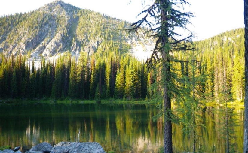
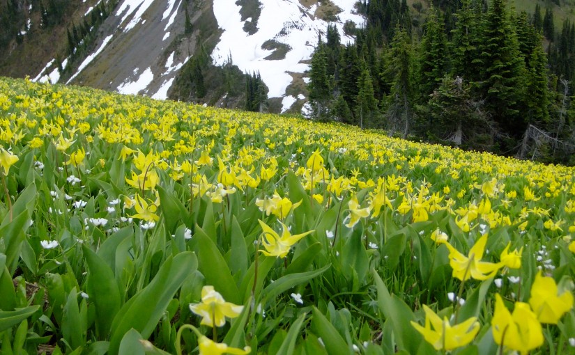
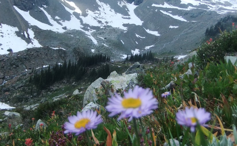
Trail 1-1.5 hr up to the Pass into Dennis Ck. Allow plenty of time to further explore ridges and flowers. Very much like a trip to Idaho Peak with more flowers, less people, more wilderness.

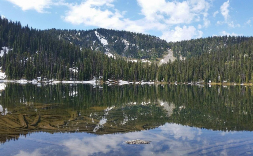
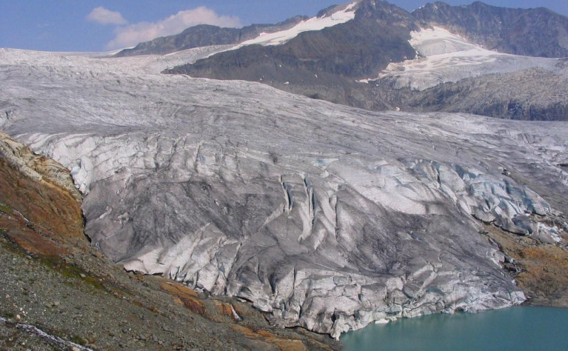
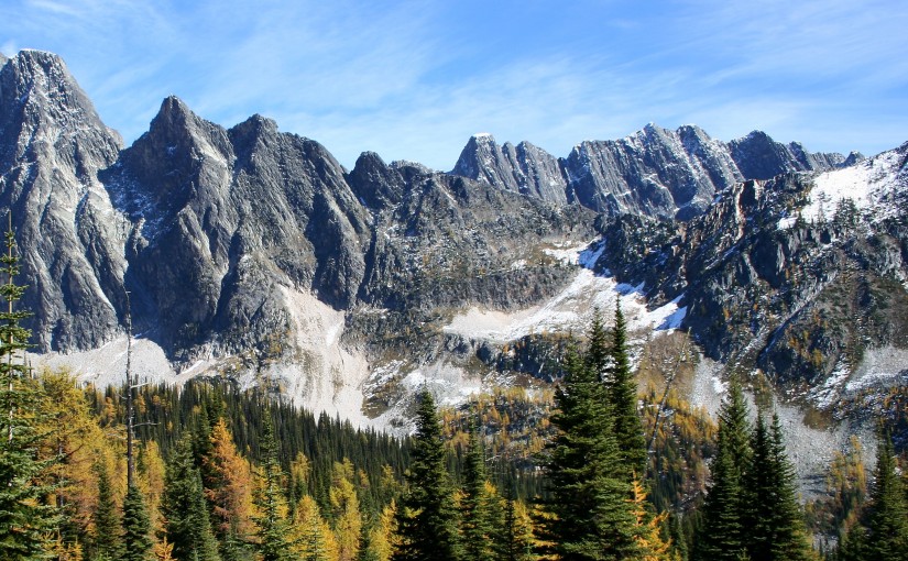
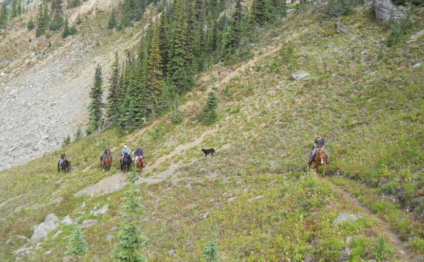
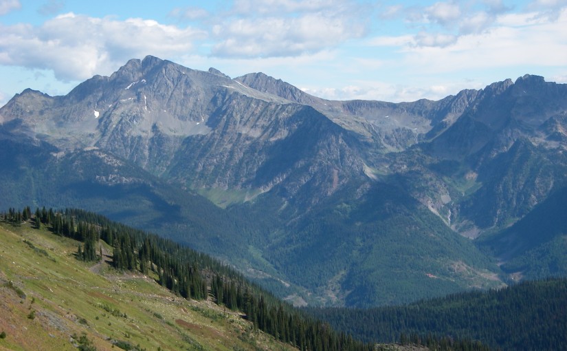
The trail to Dennis Basin begins where the 4X4 road ends. It is a steady climb with lots of excuses to stop and admire the views and the flowers. Climbing up a skid trail through an old cut block rampant with flowers, the trail soon narrows as it enters a sub-alpine forest. It continues to climb, following a small stream, emerging from the forest into a basin below the pass where frequent bear diggings warn you to be alert. You will see your destination, a low pass, up and to the left. Follow the stream to the base of the talus slope. The trail is to the left. Cairns mark the route. Early in the season, the trail may be snow covered requiring some route finding skills. As you climb steadily upward, the views unfold, and the sight of the pass ahead urges you on. The pass, which an hour and a half ago was your objective, now is a minor victory as your eyes take in the panoramic view. This is a good place to stop and have a bit of lunch while you decide which ridge to walk … which flowered slopes to explore. One of the best flower shows is usually to your left, on the ridge between Marten and Dennis Creek. From this ridge, one has spectacular views of Mt. Dolly Varden, Marten Mountain, Inverness Mountain, Mt. Dryden, Whitewater Mountain, London Ridge, Kokanee Glacier and the New Denver Glacier. A perfect place to sit and plan your next hike.

Driving Directions:Turn off Highway 6, at Rosebery, onto the “East Wilson Creek Road”. This road soon turns into the “Wilson Creek Forest Service Road”. Follow this good, 2 wheel drive, gravel road for 2.6 km. Turn right onto the “Hicks Creek Road”. From here on the road steepens and gets rougher. A high clearance vehicle with good tires is advised. 2.7 km up the “Hicks Creek Road” there is a fork in the road, stay left. The road continues to climb steadily for another 7.6 km. Look for a 4×4 post on your right, painted brown with white lettering, signed “Dennis Creek Trail 1 km “. This last bit of road is steep and rough, climbing 122 m (400 feet) in 1 kilometre. It is best suited to a 4 wheel drive, so you may want to leave your vehicle at the beginning of this last kilometre of road. Another 4×4 post, signed “Dennis Creek Trail” marks the trail head.

Mt Brennan – Lyle Ck

Popular in the Summer and Winter for ski touring and heli-skiing.

Summer Full Day: Plan on about 2-3 hours up to the lakes and 5 hrs to summit.

Lyle Creek Trail is a moderate hike to the summit of Mt. Brennan. Small glacial lakes, cascading waterfalls and scenic views are the main attractions of the area. There are also signs of old mining activities in the area. Round trip to Mt. Brennan is 15 KM, Reach the lakes in about half that.

Summer Driving Directions: From the 4 way stop in Kaslo drive highway 3A until you reach approximately 23.3 KM on your odometer and turn north onto Rossiter Creek FSR. Zero Odometer here. Stay on the Rossiter Creek FSR mainline until you reach 2.4 KM and take the left fork. At 7.0 find the trailhead. There are trail markers from the beginning of the Rossiter Creek FSR to the trailhead.

( source: Recreation Sites and Trails BC )

Winter: A very popular ski touring destination. Trail starts at bottom left of photo and traverses into drainage on right to summit on left. Follow directions for summer access and ski tour or snowmobile to start of summer trail and then continue up bench on left which is subject to danger from avalanches sluffing from upper cliffs.  At Lakes climb gully on left which is also subject to avalanche danger from above and then continue traversing right to gain upper bench system. Final short headwall has some more avalanche exposure, get the picture – don’t come here when stability is questionable. Incredible 7,000 ft day with good visibility, often wind affected and typically ascended in the spring.  More photos.

The Ride – S03E02: Giant Peaks, Tiny People from Showtime Films on Vimeo.

New Denver Accommodation Options:

Kaslo Accommodation: 

    New Denver Alpine Hikes: 

    Kaslo Alpine Hikes: 

    Ski Touring around New Denver and Kaslo:


      Mt Whitewater canyon trail

      Summer Hike: 1 hour to Whitewater Canyon for bear viewing, another hour to campsites and a further hour to end of Trail at Mine, Moraine and Glacier. 2 hours out from end of trail. Moderate elevation gain.

      Description: This trail provides access to Whitewater Glacier which is surrounded by an open glaciated landscape of small streams and small puddle-like lakes. It is a very scenic area and provides excellent recreational opportunities. Remains from past mining activities, and an old flume used to divert water, are located near the pass. Watch for mountain goats along the ridges, and be alert for grizzly bears feeding on open alpine slopes. Primary activities are hiking, viewing, camping and mountaineering. High grizzly use area, stay alert.

      Driving Directions:Head west from Kaslo on highway #31A for 28.6 km (measured from downtown Kaslo) to the old settlement of Rettallack. Turn right at the old townsite (keeping left for the first 100 m or so) and then turn right again at 0.3 km. Stay on the well-travelled portion of this road for 1.1 km to the Lyle Creek junction. Follow the left fork of the road for 2.2 km to a road on the right and take this for 0.5 km to a small parking area. This last section of the road is very narrow. You may wish to leave your vehicle at the wide area near the last junction. The trail starts 25 m past the parking area up an old road. Suitable for 2wd high clearance vehicles, although 4wd recommended.

      Also somewhat popular in the winter for ski touring, particularly in the early season when the slopes above the summer parking area are great tree skiing. Lots of options for more adventure in the upper basin. Snowmobile to access logging road helpful.

      Accommodation Options:

      More New Denver Alpine Hikes: 

      More Ski Touring in the area: