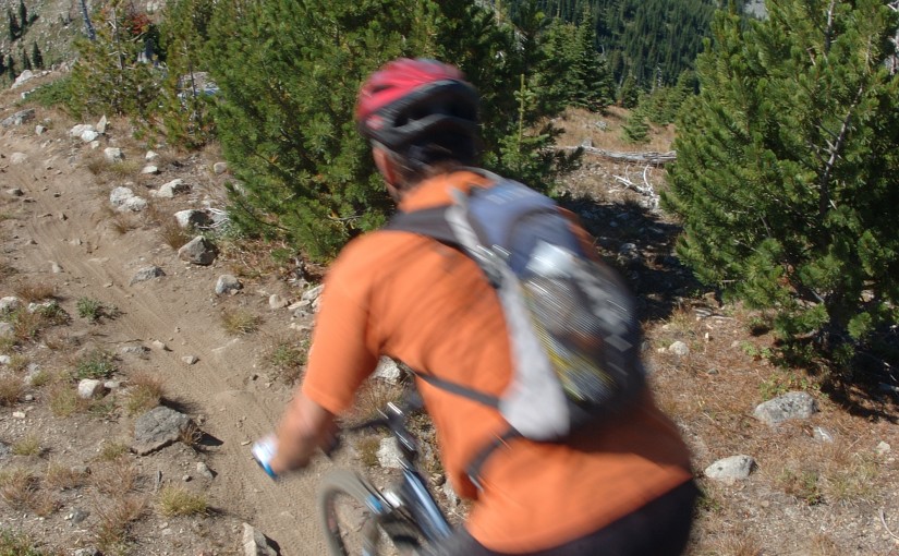
Butters is rapidly becoming one of the most popular mountain bike trails in the Slocan Valley. Access is up a steep logging road which if you are not super fit you should definitely consider shuttling this one. The climb is relentless and a little rocky. Take the first left to access lower Butters which is a little steeper and technical than Upper Butters. Lower Butters is mostly blue with some black diamond sections. Upper Butters starts from the second left and is nice and flowy. Small signposts at the trailheads but helpful to have the GPS trail information particularly for accessing the top of lower butters.
Category: mountain biking
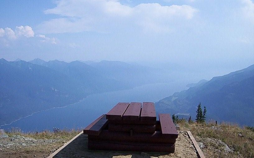
Kuskanax Creek Trail
Lots of information on trails in the nakusp region at www.nakusptrails.ca
this trail makes an awesome option to hike up, do a hot springs soak and then return, or mountain bike up and return, or a descent from the hot springs with someone else driving your vehicle for the pick up. can be easily combined with kimbol lake trail.
Beaver Lake Rec Site
This beautiful lake is found in the narrow valley of Fitzstubbs Creek, backed by the 2300 m peaks of the Nakusp Range. It is popular with family groups, as it offers something for everyone. The level sites beneath trees are suitable for tents, campers or trailers. Long weekends find folks coming from far and wide to gather for reunions, do some fishing for Kokanee and rainbow trout, swim, bike ride, play bocce and horseshoes. For those who want to get away from the crowds, a small hidden lake joined to Beaver Lake by a narrow stream, is accessible by canoe. Canoeists will also find the inlet and outlet stream interesting. Mountain biking on the Wilson Creek Forest Service Road is popular. Keep your eye open for wildlife coming down to the creek for water. Boating restriction: electric motors only. 8 campsites and a boat launch.
Driving Directions:Turn off Highway 6, at Rosebery, onto the “East Wilson Creek Road”. This road soon turns into the “Wilson Creek Forest Service Road”. Follow this good 2 wheel drive gravel road. At 5 km the road forks, stay left. Just before the orange and white 20 km marker, turn left at the “Beaver Lake Recreation Site” sign onto a good 2 wheel drive dirt road. Follow this road for 400 meters to the campsite.
Mary Simpson Cabin ( Retallack-Reco Basin )
At Retallack follow Stinson Creek FSR ( past the Retallack Catskiing lodge ) up following the left side of the creek until the road crosses the bridge and then take the left fork, continue for another kilometer or so and the cabin is right there. There is some mountain bike activity around the area now so watch for traffic from mountain bikers in the summer and snowcat skiers in the winter. Check in with the Slocan Valley Snowmobile Association and Retallack lodge for activity and closures. Overnight stays must be booked.
The area is popular with ATV’s in the summer doing the Robb Creek Trail, McGuilvary Creek and the trail over the pass into Sandon/Cody.
Retallack Lodge does helicopter and van/truck shuttles on the mountain bike trails in the area.
There are some great summer hiking opportunities from here including the summit of Mt Reco – 2 hours, Texas Peak – 2-3 hours, spectacular ridge systems with incredible views of the Goat Range, Silver Ridge and Kokanee. More photos
In the winter very busy with snowcat skiing.
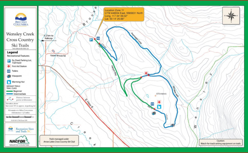
Wensley Creek Cross Country Ski Area
Wensley Creek Cross Country Ski Trails offer 9 kilometres of groomed classic track skiing for both beginner and intermediate skiers. The trail is usually ready for skiing by mid-late December, and the season extends through to late March, with variable conditions throughout the season and even along different sections of the trail. Bringing a variety of waxes is recommended. Horseback riding, hiking, and mountain biking are available in the off season.
Driving Directions:Head south from Nakusp on Highway 6 toward Nelson for about 4 kilometres, Turn left on Upper Brouse Road and follow it to the top through a series of turns until reaching the parking area for the trails.
(source: rec sites and trails )
Mt Buchanan Fire Lookout
This is a high elevation day-use site which is located at an refurbished fire lookout building. This is a great spot for family oriented outings; views are spectacular and flowers are lovely in season. There is also a 2 km loop trail below the lookout that provides access to viewpoints on the rock bluffs. Interpretive displays on fire lookouts in the tower.
Mountain Bike trails start from here ( AKA The Monster )
Driving Directions: From Kaslo, head west on highway #31A for 11 km to the Blue Ridge Forest Services Road, then follow signs. Follow the main road for 11.9 km to the lookout, staying right at the 7.0 km junction. This road is suitable for 2wd vehicles.
(source: rec sites and trails )
Sproule Creek Trail
This trail follows an old wagon trail and railroad constructed by the A.G. Lambert Lumber Co. Ltd. between 1919 and 1930. The trail provides access to the old mill site and opportunities for ridge-top hiking. The Westside loop is a cross country ski loop. It is rough and not suitable for hiking or riding. The east fork trail is a short 1.5 km (one way) trail of moderate difficulty. The gentle slope of trail gives it an “easy” rating, although there are some rough sections. The trail is used by mountain bikers, horseback riders, hunters, cross-country skiers, and hikers.
Driving Directions:From the community of Nelson, head west along highway #3A for 11.3 km to Sproule Creek Road. Follow this road for 4.0 km to the parking lot. The trailhead is located approximately 100 m up a private drive on the west side of the creek. This road is suitable for 2wd vehicles.
(source: Rec Site and Trails )
Old Glory Lookout
The Old Glory Trail is a ridge-hikers delight. The trail provides access to many kilometres of open easy ridge hiking with great views. The first section of this trail is a gentle grade that leads through a stand of large cedar and hemlock on the south side of Hanna Creek drainage and then enters an old cutblock. As the trail nears the end of the cutblock at 1.2 km the grade steepens and at times may be overgrown with alder. Hikers would be well advised to bring raingear for this section if it is wet. At 3.2 km the trail reaches a low saddle on the ridge that is called “Unnecessary Ridge” by locals. From here there are several unmanaged trails that join the main trail. Old Glory trail lies to the right, and is marked with a small sign. Turning up the ridge, the grade becomes gentler and the sub-alpine forest opens up to allow glimpse views to both sides of the ridge. The trail continues at a moderate to gentle grade, winding its way up the ridge and starting into an old burn at 4.5 km. At 6.5 km the trail reaches a junction with Plewman Trail. From here Old Glory Peak is 2.0 km. From here the trail user has the option of following Plewman Trail down the other side of the Hanna Creek drainage to the trailhead (4.5 km), or continuing on to Old Glory. The Forest Service fire lookout building perches at the very peak at an elevation 2376 m / 7795 ft. From this lofty perch 360 degree views of the surrounding areas reveal Goat Mountain and Big Sheep Creek drainage to the west, Mt. Plewman and Highway 3 to the north and east, the view back down Unnecessary Ridge, Mt. Kirkup, Grey Mountain and Granite Mountain to the east, and Esling Creek drainage to the south.
Driving Directions: From the Museum in Rossland follow the highway north for 10 km to the trailhead on the west (left) side of the highway. The trailhead can be hard to find. Look for a 4 x 4 sign post and a small grassy parking area. There is room for 2-3 vehicles at the trailhead itself, and more parking space across the highway.
( source: rec sites and trails ) – FRIENDS OF THE ROSSLAND RANGE
Idaho Peak
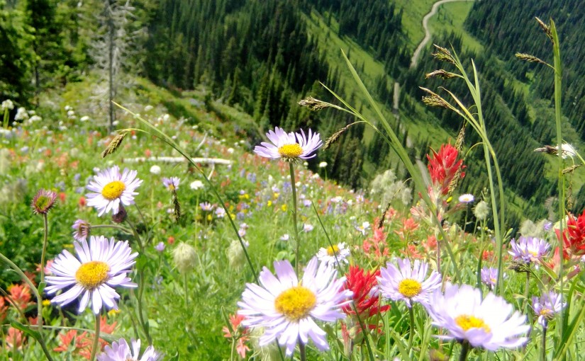
Idaho Peak offers one of the most spectacular flower shows in the Kootenays. The diversity and quantity of flowers is matched only by the diversity and quantity of visitors who come to admire the flowers and take in the 360 degree view from the lookout. This is not the place to come if you are seeking solitude. There are 2 trails to Idaho Lookout. Both meet on the ridge for the last leg of the hike up to the summit. If you would like to take the less travelled trail to the lookout, park at the Alamo parking area. The flowers along this section of the trail are every bit as showy as the ones near the ridge parking lot. Please, keep to the marked trails to avoid destroying the fragile alpine vegetation that you have come to admire. Hike is 30 min – 1 hour return trip 2 hours.
Driving Directions: At the junction of Hwy 6 and 31A in New Denver, turn east onto Hwy 31A and follow the signs to Sandon. The first 2 km of the road is wide, not too steep and well maintained by the mining companies. After this, the road narrows considerably, as it switch backs up the mountain. As you enter Wild Goose Basin, you will find a pleasant picnic site on the edge of the meadow. From here, the rest of the road is clearly visible, as it switch backs up to the 2 parking areas. The most heavily used parking area is on the ridge between Idaho Peak and Selkirk Peak. The Alamo parking area is less crowded. Perfect! Park here to avoid the crowds around the ridge parking lot. 2WD ( 30 minutes to 1 hour )
( recreation sites and trails bc )
Plan on 4-6 hours for the return journey from New Denver. In order to properly appreciate the history of this area a visit to the Sandon Museum ( open 10-5 ) before going up Idaho Peak is well worth an hour.
Popular destination for mountain biking, hiking, paragliding, wildflowers, and photography,
Accommodation Options:
More New Denver Alpine Hikes:
- Mt Whitewater canyon trail
- Mt Buchanan Fire Lookout
- Mt Brennan – Lyle Ck
- Mary Simpson Cabin ( Retallack-Reco Basin )
- Idaho Peak
- Dennis Ck
- Alps Alturas
Mountain Biking: