Cedar Grove Trail

This is one of the few pure stands of old growth Western Red Cedar in the area. The loop trail through these giants is easy enough for toddlers through to “opals” – older people with active lifestyles. The height of these western red cedar trees will have you craning your neck as your eyes follow the massive trunks towards the sky. The understorey is dominated by Lady fern and Devil’s club, so beware if you venture off the trail. This is a pleasant retreat on a hot day. Bring a picnic and enjoy the stillness and quiet of this special place.

Driving Directions:From the junction of Highway 6 and 23 in Nakusp, travel north on Highway 23 for 3 km to the Nakusp Hot Springs turn off. Take the Hot Springs road for 10.8 km. Turn left onto the “Kuskanax Creek Forest Service Road”. Follow this steep, rough, loose surface, high clearance, 2 wheel drive road for 4.2 km. Turn left onto a dirt road, signed “Cedar Grove Trail 0.8 km”. Park at the “Large Western Red Cedar Grove” sign.

Octopus Creek Rec Site

Octopus Creek flows into Lower Arrow Lake. The recreation site is located at the mouth of the creek in a crescent bay. Boaters find it a safe retreat for waiting out storms and sudden winds. During low water, there is an expansive sand and cobble stone beach. Kids can spend endless hours here playing in the water, and moving sand and rocks around. The water warms up later in the summer and is quite pleasant for swimming and board sailing. Arrow Lake is known for Kokanee fishing. However, if the fish are not biting, there is still lots to do at Octopus Creek. Hikers can hike up the creek searching for the natural hot springs. At low water there is miles of beach to walk.

Driving Directions:Due to private land issues this site has been changed to BOAT ACCESS ONLY

Wensley Creek Cross Country Ski Area

Wensley Creek Cross Country Ski Trails offer 9 kilometres of groomed classic track skiing for both beginner and intermediate skiers. The trail is usually ready for skiing by mid-late December, and the season extends through to late March, with variable conditions throughout the season and even along different sections of the trail. Bringing a variety of waxes is recommended. Horseback riding, hiking, and mountain biking are available in the off season.

Driving Directions:Head south from Nakusp on Highway 6 toward Nelson for about 4 kilometres, Turn left on Upper Brouse Road and follow it to the top through a series of turns until reaching the parking area for the trails.

(source: rec sites and trails )

Deer Creek Falls Rec Trail

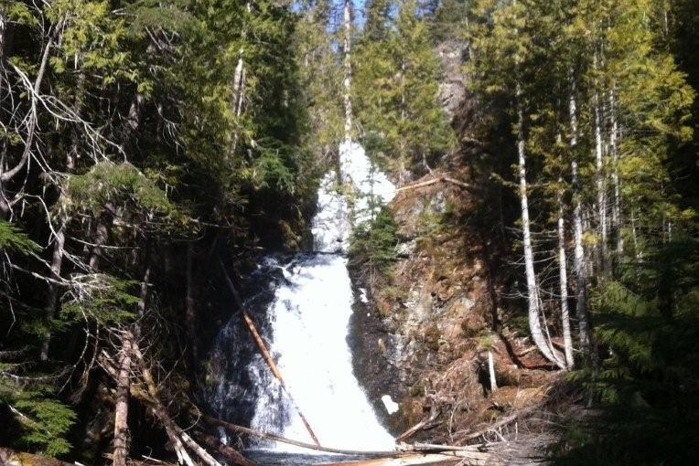
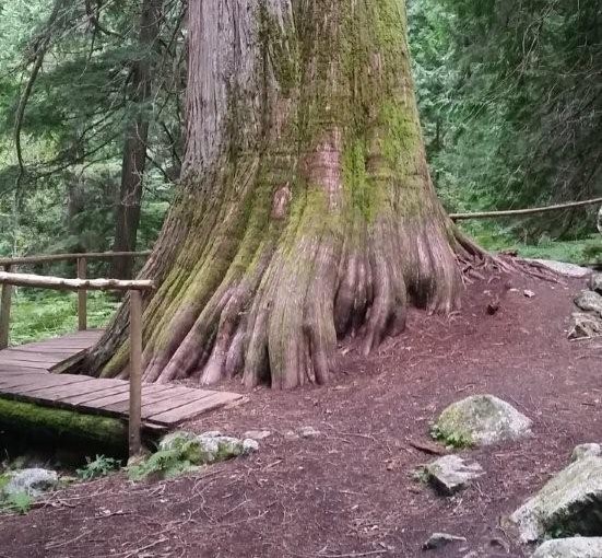
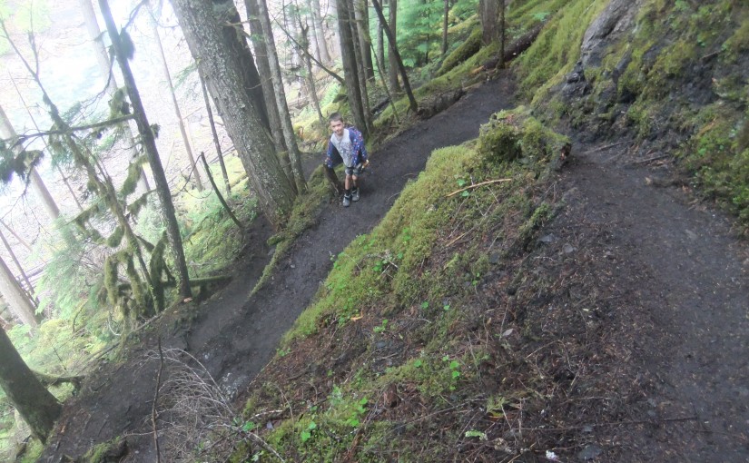
Deer Creek Falls is an easy walk on a good trail. This trail is suitable for all ages and abilities. Along the trail, are some unusually large white pine and Ponderosa pine trees. As the trail descends gently into the creek draw, the temperature drops, making this a good trail for a hot day. The Deer Creek Falls cascade in two tiers through the gorge. The upper fall is narrow and drops into a pool before cascading over the lower fall. The crystal clear pool at the foot of the lower fall invites dabbling. The entire scene is framed by a lush cedar forest. Bring a picnic lunch to enjoy at the table, while you cool off by the falls. In the autumn, look for mushrooms on the lower portions of the trail. At other times of the year, shade loving plants such as Indian Pipe can be found. On your way up the trail, rest on the bench and take in the peace and quiet of the forest. The only sounds you will hear will be the birds in the forest.

Driving Directions:Just before the yellow gates in Syringa Creek Provincial Park, turn right onto the “Deer Park Forest Service Road”. Follow this narrow, good 2 wheel drive gravel road for approximately 13.5 km. Turn right onto the “Deer Creek Forest Service Road”. Follow this road for 3.5 km. Turn off to the left, onto a dirt track. Park at the trailhead.

( source: rec sites and trails )

Kokanee Creek Old Growth Trail

This is an easy to moderate interpretive trail through an old cedar/hemlock forest. Features of the trail include large stands of huge cedar tree, lush creek side habitat, an avalanche path, and historic remains of turn-of-the-century mining and logging.

Driving Directions:Travel east of Nelson for 19.0 km on highway #3A to the Gibson Lake/Kokanee Glacier Provincial Park access road. Travel along the access road for 11.4 km to the trailhead sign. Parking for 6 vehicles is located approximately 50 meters beyond the trailhead sign. When starting the trail, keep to the left at the fork. The right fork leads down to a viewpoint.

Little Slocan Rec Site

A small, semi-open, lakeside campsite.

Driving Directions:The most popular access to Little Slocan Lakes campsite is from Passmore along Highway 6. As you drive through Passmmore heading north turn left off of the highway onto Passmore Upper Road. Cross the river and follow the road for 3.7 km. Turn left onto the Little Slocan Forest Service Rd.. Stay on the main road for approx 21 km to the recreation site on your right.

Sproule Creek Trail

This trail follows an old wagon trail and railroad constructed by the A.G. Lambert Lumber Co. Ltd. between 1919 and 1930. The trail provides access to the old mill site and opportunities for ridge-top hiking. The Westside loop is a cross country ski loop. It is rough and not suitable for hiking or riding. The east fork trail is a short 1.5 km (one way) trail of moderate difficulty. The gentle slope of trail gives it an “easy” rating, although there are some rough sections. The trail is used by mountain bikers, horseback riders, hunters, cross-country skiers, and hikers.

Driving Directions:From the community of Nelson, head west along highway #3A for 11.3 km to Sproule Creek Road. Follow this road for 4.0 km to the parking lot. The trailhead is located approximately 100 m up a private drive on the west side of the creek. This road is suitable for 2wd vehicles.

(source: Rec Site and Trails )

Wilson Creek Falls

A steep hike down to a cool, mossy waterfall. Wilson Creek Falls is considered one of the most spectacular waterfalls in British Columbia, plunging 207 feet. The hike is 2.2 km round trip. Trail is fairly flat for first 500 m and then drops down to the base of the falls. Plan on about 3-4 hours return trip from highway turn-off.

Directions: Head 5.3 km north of New Denver on Highway 6. Turn east ( right ) on East Wilson Creek FSR 11.5 km ( rough gravel road ) and then turn right just before bridge over Wilson Creek at turnoff signed for Wilson Creek Falls. A 4X4 road climbs 1km to trailhead or high clearance 2wd in 2015.