Popular hiking and alpine rock climbing destination.
Hikes:
Mt Gimli
Mt Dag
Alpine Climbs:
Mt Gimli
Mountains:
Popular hiking and alpine rock climbing destination.
Hikes:
Mt Gimli
Mt Dag
Alpine Climbs:
Mt Gimli
Mountains:
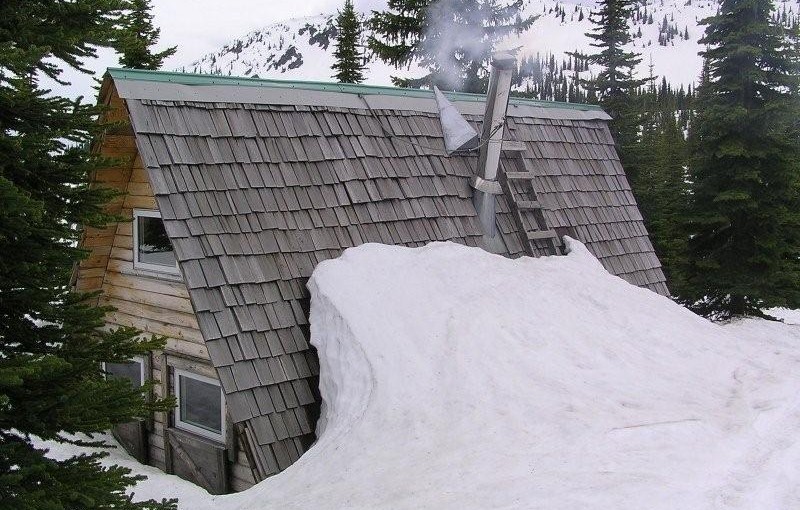
At 2320 metres, Siwash Mountain is the highest peak in the Bonnington Range, and the Steed Cabin, a snug wood cabin built by the KMC in 1995, lies due south of the summit of Siwash Mountain by a small tarn at 2100 metres. A loft in the cabin can sleep four (no foam mattresses), while the downstairs is equipped with table, bench seats and a wood stove. Basic cooking utensils (pots, pans, cups, bowls, plates, cutlery, etc.) are stored in a plastic bin. There is also a two burner white gas Coleman Stove and Coleman Lantern (take spare mantels). You will need to bring your own white gas for the stove and lantern. There is NO water at the Steed Cabin in either summer or winter. The area around the Steed Cabin is popular with snowmobilers, so expect to see snowmobilers when you are staying at the cabin.The cabin is maintained under partnership agreement with Kootenay Mountaineering Club. For detailed information and driving directions please visit: http://www.kootenaymountaineering.bc.ca
Driving Directions: In winter, it takes two days to reach the cabin via the Bonnington Traverse route. In the summer, a four wheel drive vehicle is not necessary. It is possible to drive to the head of Glade Creek, from here, it is between one and three hours of bushwhacking (thick bush with many black and grizzly bears in the area) to reach the cabin. Follow the following driving directions for summer access. Set your odometer to 0 on Highway 3 at Bombi Summit. 0 km = Munson Road and Highway 3, 2.6 km = powerline spur to (R) 3.7 km = Lower Munson to (L), stay (R), 3.9 km = West Munson to (L), stay (R), 5.4 km = East Munson to (R), stay (L), 6.3 km = spur to R, stay on mainline, 6.4 km = spur to (R) is Grassy access, 10.8 km = small pass, road enters from behind and (L), stay straight down the hill, 11.0 km = road forks, go (R) to stay on Munson Road, (L) fork is North Munson, 15.1 km = pass below Twin Peaks, 18.9 km = fork in road, go (L), 22.6 km, = park here and walk the rest of the way.
( source: rec sites and trails )
There are three different access routes to the Silvercup ridge, choose the one you are interested in. Via American Creek Road: From the boulder barricade to the ridge, the trail follows the road through subalpine and alpine terrain. Panoramic views into the Lardeau Range and Goat Range and an abundance of wild flowers enhance the walk up to the ridge. Upon cresting the ridge, there is an intriguing view into Healy Creek and across to Mt. Aldridge and Razors Edge. The Silvercup Trail offers a superb opportunity to enjoy an extended ridge walk through alpine and subalpine terrain. If the entire ridge is walked, it is 25 km from the trail head on American Creek road to the trail head on Dirt Road. There is not a continuous trail along the ridge, it is a combination of clearly defined trail and cairned route. Good footgear, map reading and navigation skills are required. Travelling the ridge in poor weather is not recommended. Via Copper Queen Road: The Copper Queen Road offers road access onto one of the most beautiful ridges in the Arrow and Kootenay Lake Forest Districts. Upon reaching the ridge one has a choice of either following the trail northwest along the ridge to the Dirt Road trail head, or heading southeast to the trail head on American Creek. If you are using the road, it peters out near the timberline on the Dirt Road trail and is blocked by boulders on the American Creek Road. Via the Dirt Road: The first 0.5 km of the trail may be difficult to follow, as it cuts up and back across a harvested area. Silvercup Ridge offers a superb opportunity to enjoy an extended ridge walk through alpine and subalpine terrain. Views into the Badshot Range and across to the Lardeau Range are spectacular. Visitors to this area will wish they had more time to go over the “next ridge” as there are many opportunities for side trips all along Silvercup Ridge.
Driving Directions:Access to American Creek Road : From the bridge over the Lardeau River at Gerrard, proceed north on Hwy #31 for 0.4 km to an unsigned road. Proceed for 4.1 km on this unsigned road to a junction on a curve. Stay straight ahead at this junction, following an older, brushed in road. At km 6.9 take the switch back to the left and up. This section of the road has steep sections with windfalls and is eroding in places. From 8.7 km, to the trail head at 11.9 km, you will require a 4×4 vehicle, or you can shoulder your pack and walk up the road. At 11.9 km, boulders block the road to all vehicular traffic. There is a parking area for about 3 vehicles, with room to turn around. Access to Copper Queen Road: From the bridge over the Lardeau River at Gerrard, proceed north on Hwy #31 for 17.9 km to an unsigned road. Turn right and proceed up this road for 6.2 km. Then, take a small, older road that turns back and up to the right. Follow this old road for 1.9 km to a fork in the road. Take the left fork and continue 0.5 km up to the timberline. From here you will need a 4×4 to go the last 0.7 km to the mining road that runs along the ridge. Although it is possible to drive almost the entire length of Silvercup Ridge on this mining road, please, refrain from leaving the road as the alpine and subalpine meadows are very fragile. The original old trail can be accessed by foot from many places along the mining road. One of the best places is just where the Copper Queen Road meets the road along the ridge. From here the trail is just above the mining road. Access to Dirt Road: From the gas station on Hwy #31 in Trout Lake, proceed south on Hwy #31 for 8.3 km to an unsigned road. Turn back and up onto this road. A high clearance vehicle will be required to negotiate the water bars. Follow this road (driveable for 1.8 km) for 3.2 km to the trail head. The trail head may be hidden by alders. Keep a sharp eye open for a 4×4 brown post with white letters on the uphill side of the road.
( rec sites and trails )
Summer Hike: 1 hour to Whitewater Canyon for bear viewing, another hour to campsites and a further hour to end of Trail at Mine, Moraine and Glacier. 2 hours out from end of trail. Moderate elevation gain.
Description: This trail provides access to Whitewater Glacier which is surrounded by an open glaciated landscape of small streams and small puddle-like lakes. It is a very scenic area and provides excellent recreational opportunities. Remains from past mining activities, and an old flume used to divert water, are located near the pass. Watch for mountain goats along the ridges, and be alert for grizzly bears feeding on open alpine slopes. Primary activities are hiking, viewing, camping and mountaineering. High grizzly use area, stay alert.
Driving Directions:Head west from Kaslo on highway #31A for 28.6 km (measured from downtown Kaslo) to the old settlement of Rettallack. Turn right at the old townsite (keeping left for the first 100 m or so) and then turn right again at 0.3 km. Stay on the well-travelled portion of this road for 1.1 km to the Lyle Creek junction. Follow the left fork of the road for 2.2 km to a road on the right and take this for 0.5 km to a small parking area. This last section of the road is very narrow. You may wish to leave your vehicle at the wide area near the last junction. The trail starts 25 m past the parking area up an old road. Suitable for 2wd high clearance vehicles, although 4wd recommended.
Also somewhat popular in the winter for ski touring, particularly in the early season when the slopes above the summer parking area are great tree skiing. Lots of options for more adventure in the upper basin. Snowmobile to access logging road helpful.
Accommodation Options:
More New Denver Alpine Hikes:
More Ski Touring in the area: