Location: New Denver Area
Time: Plan a full day. Long drive (25km) on rough 2wd road. Lots of scrambling options at the end of the trail. Drive 1hr from New Denver. Hike 3-4 hr return.
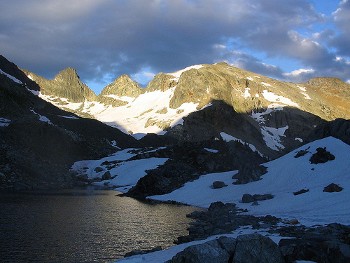
The Alps Alturas trail is a hikers paradise. Alpine flowers, mountain goats, wild rocky vistas, glacial lakes, water falls… it all awaits the hiker with perseverance. Climbing from the trail head through an old cut block, the trail soon picks up an old mining access road. Near the end of the road, the trail takes off to the left, climbing up through the sub-alpine forest to meadows. Frequent bear diggings warn you to be alert, as you are in bear habitat. Between 2.5 km and 3 km on the trail, a short side trip to your right, between rocky knobs, will take you to the old fallen down mine cabin of the Alps Alturas Mine. From here there is a beautiful view of the ridges of Dennis Basin. Now, the slope becomes steeper as the trail angles upward across talus slopes. The first turquoise lake you see will be at your feet, 396 meters (1300 feet) below you, connected to the lakes above by a thread of falling water. Marten Mountain and Inverness Mountain loom ahead. The “beep” of pikas and the shrill whistle of marmots warn other wild life of your presence. Rounding a corner, a raw and rugged landscape comes into view. As you pick your way across the talus, mountain goats scramble along the rock ledges below a remnant glacier. Four glacial lakes rest between Mt. Dolly Varden and Marten Mountain in a landscape of rock and ice.
Driving Directions: Turn off Highway 6, at Rosebery, onto the “East Wilson Creek Road”. This road soon turns into the “Wilson Creek Forest Service Road”. Follow this good, 2 wheel drive, gravel road for 2.6 km. Turn right onto the “Hicks Creek Road”. Reset your odometer, as there are very few kilometre signs on the “Hicks Creek Road”. From here on the road steepens and gets rougher. A high clearance vehicle with good tires is advised. 2.7 km up the “Hicks Creek Road” there is a fork in the road, stay left. At 10.3 km on your odometer you will pass the Dennis Creek Trail turn off. From here the road is narrow. At 19.7 km stay to the left. At 22.3 km on your odometer, continue straight ahead to the upper cut block. In 300 meters stay left and down, crossing over a culvert. At 23.4 km a brown 4×4 post with white lettering, signed “Alps Alturas Tr”, will direct you to the left. Continue for another 2 km, back across the cut block. Park at 25.4 km, at the 4×4 post marking the trail head.
( recreation sites and trails bc )
Accommodation in New Denver:
- Valhalla Ski Traverse – Valhalla Provincial Park
- Beatrice Lake – Valhalla Provincial Park
- Whitewater Ski Area
- Butters
- Kuskanax Creek Trail
- Valhalla Provincial Park
- Mt Gimli
- London Ridge
- Kootenay Winter Web Cams
- Backcountry Skiing Daily Preperation
Other Alpine Hikes:
- Valhalla Ski Traverse – Valhalla Provincial Park
- Beatrice Lake – Valhalla Provincial Park
- Whitewater Ski Area
- Butters
- Kuskanax Creek Trail
- Valhalla Provincial Park
- Mt Gimli
- London Ridge
- Kootenay Winter Web Cams
- Backcountry Skiing Daily Preperation
Request further information: