Kututle Bowl

Location: Whitewater Ski Area.
Time: Full day
Difficulty: Difficult
Distance: Long
Elevation_Gain: lots of meters
Map: 82 F/6
Avalanche Exposure: Complex

Climb to the summit of Half Dome, or the notch between Ymir Peak and Half Dome and descend into Kututle forever. There are tons of lines out here and a more wilderness feel than any of the other touring areas around Whitewater.

Blaster’s Ridge & Prospector’s

Location: Whitewater Ski Area. Purchase a single ridge ticket and ride the Summit Chair.
Time: Half day
Difficulty: Moderate
Distance: Short
Elevation_Gain: 200 meters
Map: 82 F/6
Avalanche Exposure: Challenging

From the top of the Summit Chair ski left along the run on the top of the ridge. Stop at the top of Motherlode and look for the Ski Patrol Warning Sign in the little dip before the traverse. The route stays closely on the ridge and is used by the Ski Patrol as a safe route to the top of their blasting run during high avalanche conditions. After numerous tight switchbacks the top of the ridge is gained. A steep tree glade named “Garbage Chutes” is an exciting descent next to the route of ascent. There are a series of progressively steeper lines ( N facing ) that continue for the next kilometer along this ridge. The trip out to Sherpa Valley takes the flat ridge to the South with cliffs lining the right hand side. After five hundred meters you will break into a small bowl, known as Sherpa Valley. If you would continue further along the ridge you end up dropping down very low km7 on the access road and Mama and Papa Bear Chutes are down that way too. Alternatively traversing left above the ski area takes you to Prospector Bowl which has some amazing steep lines leading back into the ski area. Climbing further past from Prospector’s takes you into the entrance for West Ymir and continuing on from there takes you to the summit of Ymir Peak along with the south facing lines H8 and the south face of Ymir Peak.

Ymir Peak & Bowl

Location: Whitewater Ski Area
Time: Half day – Full Day
Difficulty: Moderate
Distance: 3km
Elevation Gain: 1500 feet
Map: 82 F/6
Avalanche Exposure: Complex

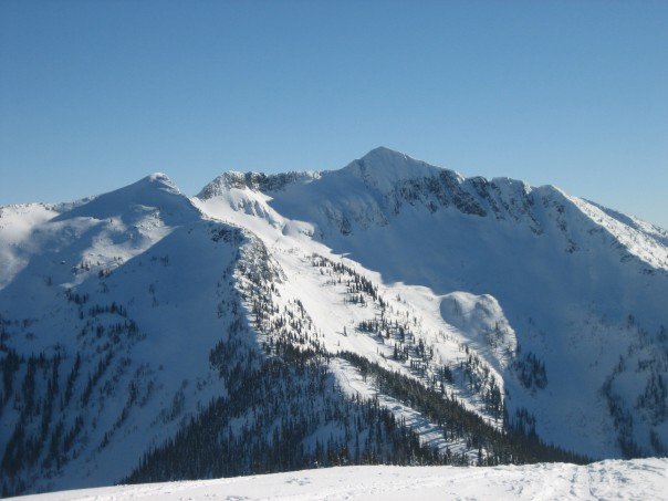
A number of options are available to gain access to Ymir Bowl and Ymir Peak. The ridge line from Blasters ridge to the summit is the longest route but the most scenic and safest. Alternatively from the White Queen Pass climbing up the ridge and traversing high under the rocks over steep terrain and gaining the ridge. The ridgetop is called Half Dome and good runs can be made form here into Five Mile. From just below the final climb to Half Dome a traverse can be made into Ymir bowl. Ymir Bowl is not a good place to be unless Avalanche conditions are very stable. Once in the bowl Kututle Pass is an interesting destination or Ymir Peak can be gained from the bench just to the left of the Peak. The route to and from the Peak involves careful manoeuvring on rocks and snow on the steep East slopes of Ymir Peak.

Ymir Bowl From lookers left to right

Five Mile Saddle above the lift, Goat’s Slide, Half Dome, Scob’s Knob ( the treed knob within the bowl ), Kututle Notch, Cookie Cliffs, Kuba Chute, Ymir Peak, Dogs Leg, First Choice, Pencil Chute, West Ymir, and Prospector’s Bowl at the edge of the ski area.

Barrett Lake

Barrett Lake is a beautiful little mountain lake with a small rustic cabin on the shores. There are opportunities for Quading, hiking, fishing, and camping. Barrett Lake is at 1800 Meters. Popular in the winter for snowmobiling and ski touring.

Driving Directions: Access to the Barrett Lake is via Porto Rico Road, 15 km south of Nelson off Highway 6. In summer you can drive up 3 km and park there. (Recommended Quad Access Only from this point). From here you take the lower fork in the road up another 3 km (this section of road is deactivated but is passable in a high clearance 4X4) to a junction, take a right here (about 6 KM up in total). From here, follow the really rough and rocky road for another 4.5 Km up to the lake, stay on the main road on the way up. The last 4.5 Km is extremely rough, and heads to the East up the drainage crossing a South facing rocky slope.

Erie Creek Rec Site

The Erie Creek Recreation Site is one of the few recreation sites large enough to accommodate groups of 3 or 4 vehicles. The sites are in a semi-open forest, offering shade in the hottest part of the day. Located beside crystal clear Erie Creek

Driving Directions:From the junction of Highway 3B and 3/6 in Salmo, travel 3.6 km west towards Trail, on Highway 3. Just before a small bridge over Erie Creek, turn right onto the “Second Relief Road”. This road is paved for the first 200 meters, then turns into a good 2 wheel drive gravel road. Within 1 km you will see the “Erie Creek Forest Service Road” sign. Continue up this road. The road forks at 7 km, stay straight ahead (to the left). The road forks again at 8.5 km, again stay left, descending into the valley. Cross over the bridge, at 10 km. The recreation site is on your right.

( source : Rec sites and trails )

Giveout Creek Cabin

The cabin overlooks the Nelson Valley at an elevation of 1730 Meters. The cabin is primarily used for a warming hut for snowmobilers. There are a few bunks in the cabin for overnight use. There is good snowmobiling in the cut blocks surrounding the cabin and in and around the old mining sites.

Driving Directions:The cabin can be accessed off of Hwy 8 to Ymir out off Nelson. Turn east onto Giveout Creek FSR for +/- 1.6 km and then onto Gold Creek FSR for +/- 5 Km, then bear right at the junction. Follow this road for 3 more KM . At this point there is an old logging skid road for 300 meters up to the cabin. There is usually lots of snowmobile tracks leading to the cabin. The trail in is occasionally groomed by the nelson sno-goers club. Cabin Location is N49�25.602 W117�17.722

more information at http://nelsonsno-goers.webs.com/

Huckleberry Hut

Huckleberry Hut is a cosy log cabin situated at around 1600 metres in the valley below Midday and Cabin Peaks. It is a small hut with two bunks (no foam mattresses) which will each sleep two. There is also a fold-down table, wood stove and outhouse, and basic cooking utensils (pots, pans, cups, bowls, plates, cutlery, etc.) There is a two burner white gas Coleman Stove and Coleman Lantern, bring spare mantels and white gas. The cabin is maintained under partnership agreement with Kootenay Mountaineering Club. For detailed information and driving directions please visit: http://www.kootenaymountaineering.bc.ca

Driving Directions: Access to the Huckleberry Hut is via Porto Rico Road, 15 km south of Nelson off Highway 6. In summer, with a high clearance four wheel drive vehicle you can drive for six kilometres to a junction where an old road leads off to the left. Park here, and walk the remaining two kilometres to the cabin. In winter a combination of snowmobiles and ski touring gear may be required. The cabin is maintained under partnership agreement with Kootenay Mountaineering Club. For detailed information and drining directions please visit: http://www.kootenaymountaineering.bc.ca/huckleberry.html